Table of Contents
Rethinking Maps
Solarpunk settings are often stateless or trending in that direction, and for good reason.
Borders in the modern world are frequently arbitrary, and incredibly harmful to communities, cultures, and ecosystems. Because they're often based on geographical choke-points or barriers for military engagements rather than the local culture, language, or management of resources, borders often sever communities and biomes.
Two communities that share a river are not naturally different peoples because they live on opposite banks. They need to be able to coordinate their activities to properly manage their shared biome, and that work is complicated by the existence of states and borders.
Other borders are drawn based on nothing more than invisible longitudinal lines chosen because they’re a nice round number in a numerical system invented by Babylonian astronomers. They are treaties based on the expected resource extraction divvied up by the rich people who run the states, again with no consideration for the cultural and biological regions these compromises compromise.
These arbitrary lines divide neighbors who would otherwise move freely and during long stretches of peace, the land and people resist these unnatural constraints.
If you're planning a solarpunk setting it's still tempting to redraw the map and include some kind of regional divide. If you're looking for alternatives to nation states and existing borders, perhaps consider the following:
Watersheds


In a world where states no longer exist, borders drawn by nature may be very useful for administrative purposes. People will still need to coordinate over land and water management.
Water is critically important to any human society and we've seen real life examples of problems that occur when the upper and lower parts of a river have been separated by nation state boundaries, or even federated state borders within a nation.
One nice aspect of watersheds is that they though their boundaries are defined by nature their scope can be sort of arbitrary, and they can be subdivided down with ever-more specificity. That means you can generally scope these administrative zones to be as large or small as you need for your story, from huge nation-sized chunks of land all the way down to tiny town-sized areas, or even to specific streams.

Watersheds as administrative areas could also provide some wonderful worldbuilding possibilities. If your setting is in the transition to a post-state world, but is not there yet, then there’s excellent potential for factions, feuds, drama, and plot hooks in the existing states losing relevance to watershed organizations that overlap their territory and authorities, but don’t necessarily encompass all of them.
There will also still be plenty of room for conflict within these administrative areas. For example, even if a state or province border doesn't divide the upper and lower half of a river, the upstream and downstream communities encompassed in that watershed may be very different in culture and in how they use the river. A watershed management council would have to navigate the competing visions of large and populous arcologies at the river forks and the sparsely populated but upstream river highlands. How would this organization mediate between the interests of the two groups? If it was directly democratic, would the highlanders feel politically impotent compared to the more populous lowlanders? How far would the river people go to enforce their vision of water management on the culturally distinct stream tenders?
Biomes and Hardiness Zones
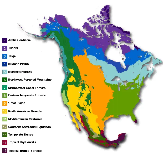

Depending on what's being managed, dividing things by biome or hardiness zone might make more sense. These are another natural boundary, though often a softer one than the watersheds.
It's possible that these could be used at the same time as each other, and as the watersheds, if different systems are used by different bureaucratic microservices where various responsibilities currently glomed together in government would be broken out into many separate, single-purpose organizations.
Land Back

If your setting involves successful Land Back movements you might want to draw some inspiration from the overlapping zones of the historical lands of indigenous peoples. Though it's also worth considering the present day reservations in the US and Canada as those are also home for many people today.

This option is going to need some special consideration, as there is a tremendous amount of traumatic history shaping the present status quo and a lot of entrenched changes between the above maps.
Sovereignity is a key pillar in land back and different First Nations / Native communities and individuals are going to have very different ideas about the best way to utilize a space. These often don't conform to stereotype or outside expectations about what indigenous communities should want to do with their land. Identifying a realistic shape for this future will require input from the specific people concerned, or especially careful research if you're not a member of the group.
For a look at the historical territories, this interactive map is very useful: https://www.npr.org/2022/10/10/1127837659/native-land-map-ancestral-tribal-lands-worldwide
Though in anything short of alternative history you're likely going to want to use some hybrid of historical territories and modern landmarks.
All of The Above
There’s no need to restrict yourself to just one new way of redrawing the map. Societies are messy, and though they're often slow to change, multiple groups may be working on different changes at the same time. It wouldn’t be unrealistic to end up with a mix of all of the above, along with existing cities and state or national borders too. Here’s one example, from an impressive alt-history project.
This page, (like all the rest in this wiki) is a work in progress. If you have ideas on other ways to redraw a map or see something needing correction, please reach out!