
This is an old revision of the document!
Rethinking Maps
Solarpunk stories are often stateless or
States are an absurd construct in modern times, and even more absurd in a solarpunk context. Borders are often based on geographical choke-points for military engagement rather than the culture, language, and peoples who live in the region torn by the arbitrary lines of martial conquest.
Two communities that share a river are not naturally different peoples because they live on opposite banks. They have to coordinate their activities to properly manage their shared biome, and that’s complicated by the existence of states that seek to divide them. During long stretches of peace, the land resists these unnatural constraints. Treaties that govern territories are dead as the tree pulp they’re written on, but rivers and mountains are alive, and their erosion and meandering redraws maps and cultural regions, creating political enclaves out of river bends.
And that’s the best case when it comes to border logic: often borders are drawn based on invisible longitudinal lines chosen because they’re a nice round number in a numerical system invented by Babylonian astronomers. They are treaties based on the expected resource extraction to be shared by competing warlords, again with no consideration for the cultural and biological regions these compromises compromise. The state is an affront to nature.
This at least avoids the absurdities of modern borders, which often divide communities
Watersheds
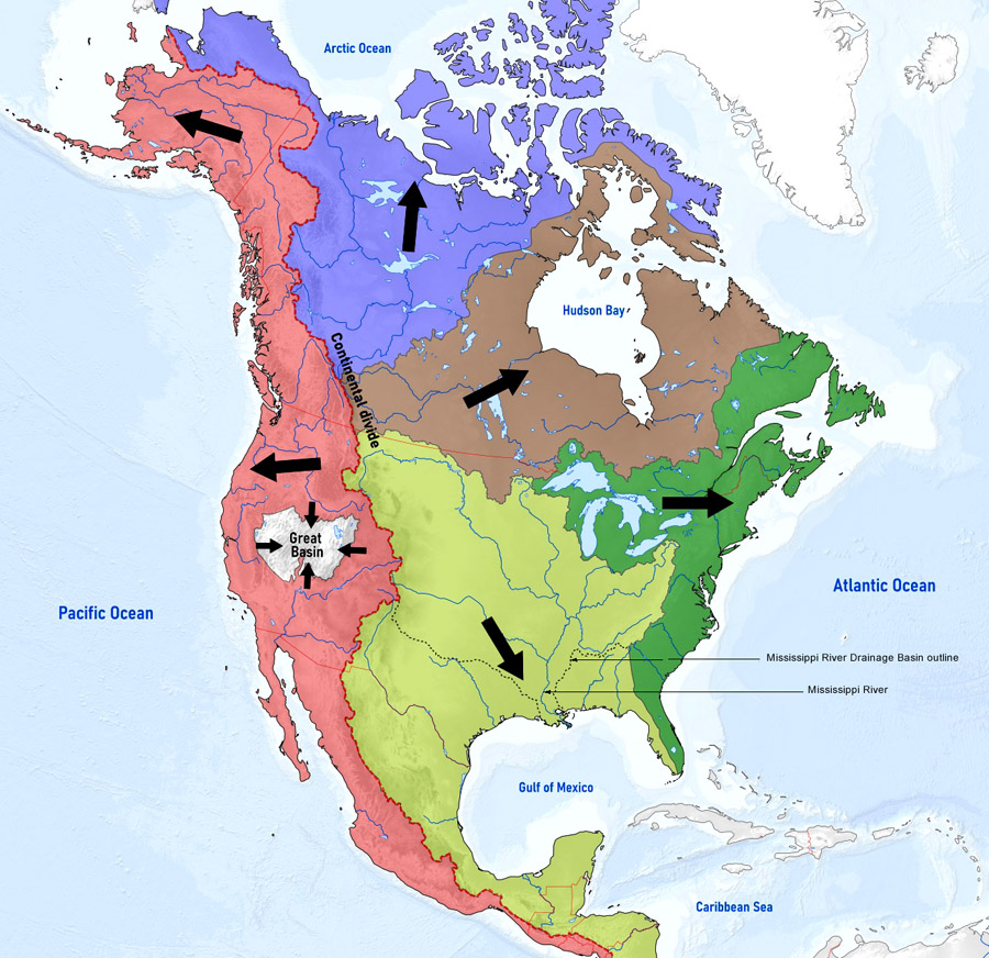
In a world where states no longer exist, borders drawn by nature may be very useful for administrative purposes. People will still need to coordinate over land and water management.
Water is critically important to any human society and we've seen real life examples of problems that occur when the upper and lower parts of a river have been separated by nation state boundaries, or even borders within a nation.
One nice aspect of watersheds is that they can be subdivided with ever more specificity. That means you can generally scope these administrative zones to be as large or small as you need for your story, from huge nation-sized chunks of land all the way down to tiny town-sized areas, or even specific streams.
Watersheds as administrative areas could also provide some wonderful worldbuilding possibilities. If your setting is in the transition to a post-state world, but is not there yet, then there’s excellent potential for factions, feuds, drama, and plot hooks in the existing states losing relevance to watershed organizations that overlap their territory and authorities, but don’t necessarily encompass all of them.
There will also be plenty of room for conflict within these
Depending on what's being managed, dividing things by biome or hardiness zone might make more sense